Wednesday, February 22, 2012

The Geography of Government Benefits

Accompanying this post, is a map showing county-level data illustrating per capita income from government programs such as Social Security, Medicare, Medicaid, veterans’ benefits, and unemployment insurance. The interactive map allows you see not only geographic patterns but also change over time. The maps present data from the years 1969, 1979, 1989, 1999, and 2009. What you don’t see included on this map are things such as farm and/or timber subsidies.

Check out your own county. You won’t be able to resist comparing it to neighboring areas and viewing the amount of change over the years. Trying to explain these patterns is at the heart of geography.

Link to interactive map:  http://www.nytimes.com/interactive/2012/02/12/us/entitlement-map.html?ref=us


Monday, December 26, 2011

SP's Willamette Pass


Here is my latest map creation using ArcGIS Explorer and Inkscape. This is a map that shows the former Southern Pacific mainline between Oakridge, Oregon and Willamette Pass. Overall this came out pretty well using the shaded relief base map. There is also a National Geographic Basemap available; however, it is cluttered with too much text. Please feel free to offer any comments, corrections, or suggestions. Thanks.

Saturday, December 24, 2011

Cartography on the PC

I recently downloaded some free software from ESRI called ARC GIS Explorer. I was working with it this weekend to see what it could do. Attached is a copy of a map I designed today, recreating a map that appeared in the August 2005 issues of Trains Magazine.

This program allows you to design thematic maps (background information including shaded relief and administrative boundaries) as well as add layers (green for the POTB Railroad). Final editing was done in PowerPoint which included text and symbols (city dots and highway markers). Fancier editing could be done in Adobe Illustrator; however, I was amazed how much I could do in PowerPoint. I just downloaded a free version of Inkscape, as that may be able to do some of the advanced editing techniques found in Adobe. Let me know your thoughts, comments or suggestions.

Monday, October 4, 2010

Milwaukee Road Depot - Cle Elum, WA

This past weekend Linda and I had the opportunity to visit the Milwaukee Road depot in Cle Elum, Washington. This is definitely worth the stop if one gets the chance when traveling along I-90 between Seattle and Spokane.

The Chicago, Milwaukee, St. Paul and Pacific Railroad (Milwaukee Road) South Cle Elum Rail Yard located in South Cle Elum, Washington, was a division point on the Chicago, Milwaukee, St. Paul and Pacific Railroad's Coast Division. It was established by the railroad in 1909 during construction of its "Pacific Extension".

After the completion of the first two transcontinental railroads into the Pacific Northwest, the Northern Pacific Railroad and the Great Northern Railway, The Milwaukee Road decided that in order to compete, it too must expand into the Northwest. It began construction on the Pacific Extension in 1906 and completed the rail line into Tacoma, Washington in 1909.


The Milwaukee Road placed division points approximately every 100 to 150 miles (240 km) apart. The division point was where locomotives were serviced, where train crews came on and off duty, and where trains were sorted and rolling stock stored. In addition, depots or stations were also placed at division points in order for passengers or freight to get on or off trains. Here is a picture of the depot before restoration.

The division point at South Cle Elum was placed between the terminus at Tacoma and the next division point at Othello, Washington. Thus South Cle Elum was the last crew change westbound before crossing the Cascade Range at Snoqualmie Pass and going into Seattle, Washington; as well as the first crew change eastbound from Seattle to Othello and beyond to the Midwest, the Twin Cities and Chicago, Illinois.

The rail yard at South Cle Elum consisted of the depot, the roundhouse (now a ruin), the turntable (also a ruin), ash pit, water tank (now a ruin), and the bunkhouse where train crews spent time between shifts. After The Milwaukee Road electrified around 1920, an electric substation and substation operators' residences were also built at the rail yard.

In 1980 The Milwaukee Road ceased service in Washington. It sold off much of its property. The bunkhouse became a bed and breakfast, the substation operators' houses were taken over by private individuals who continue to live in them. In lieu of paying back taxes, the railroad transferred ownership of the main line and infrastructure to the state. Because of the integrity of the buildings as well as the integrity of the setting, the rail yard and associated buildings were listed in the National Register of Historic Places in 2003. Click on the aerial photo for more detail.

The Depot and Cafe is located on 801 Milwaukee Road, South Cle Elum, WA 98943. The phone number is (509) 674-2006. Their website is http://www.milwelectric.org/. Here is a map of the location (click on the image to enlarge the map). Located inside the depot is the Depot Café restaurant http://www.thedepotcafe.com/. Also located adjacent to the depot is the Iron Horse Bed and Breakfast http://www.ironhorseinnbb.com/.

Here is a topographic map of the site (click on the image to enlarge the map).

Friday, January 22, 2010

Sky Palm Motel – Orange, CA

Here is a neat googie jem, located right in the middle of the Tustin Avenue commercial district in Orange, California. This place features a cool neon sign out front, as well rock walls (similar to that of Pann’s), and palm trees.

Motel at night. The a-frame roof at the motels entrance exemplifies the mid-century modern geometric shapes.


Here is a picture of the both the "Motel" pole sign and the neon "vacancy" lit up for the evening.


Here is a close up of the neon portion of the sign.


The Sky Palm Motel is located on 210 N. Tustin St., Orange, CA. The phone number is
(714) 639-6602. Here is a map of the location.

Monday, January 18, 2010

Santa Fe Depot - Orange, CA

The Atchison, Topeka and Santa Fe Railway Depot in the City of Orange, California, is currently used as a stop on Southern California’s Metrolink (Orange County Branch), as well as Amtrak’s Pacific Surfliner.


The current depot structure was dedicated on May 1, 1938 and was closed with the Santa Fe's discontinuation of passenger service in 1971. The building was granted historic landmark status by the City of Orange on November 15, 1990.

The Santa Fe, under its affiliate the Southern California Railway, laid the first tracks through Orange in 1886 and established its first depot the following year. During peak growing seasons, as many as 48 carloads of citrus fruits, olives, and walnuts were shipped daily from the Orange depot as well.


Here is a close up of the art deco sign.


For those interested in visiting the depot, it is located at 100 N. Atchison Street,
Orange, CA 92866

Sunday, January 17, 2010

Randy's Donuts - Los Angeles (Inglewood)

Randy's Donuts (locally known as the "Big O") is a classic example of programmatic architecture that had its heyday between the mid-1920’s and the mid-1930’s. Randy’s is located Inglewood, California near Los Angeles International Airport.


Randy's was built in 1953 as the second location of the now-defunct Big Donut Drive-In chain by Russell C. Wendell, a donut machine salesman. The product is represented by a 32-foot doughnut on the roof of an otherwise ordinary drive-in. The building was designed by Henry J. Goodwin.

Recently, Randy’s Donuts was featured in a local Los Angeles television show called “Cheap Eats.” http://www.youtube.com/watch?v=F8QjBgiIaRE

For those interested in visiting Randy’s Donuts, you can check it out on the web http://www.randys-donuts.com/ or visit them in person at 805 West Manchester Avenue, Inglewood, CA 90301. Phone number is (310) 645-4707.

Saturday, January 16, 2010

Chip's - Los Angeles (Hawthorne)

This googie gem opened in 1957, and was designed by architect Harry Harrison. Key characteristics of this restaurant include the concrete walls, glass windows, jutting roof, plant life, and the steel-beam pylon sign.


Chip's is a great-looking example of mid-20th century Googie-Style architecture. This type of modernistic, space-age architecture is called "Googie" after the coffee shop of the same name designed by John Lautner in 1949.


This neighborhood diner near LAX has changed little since it first opened its doors. The counter seating, a feature borrowed from submarine design, enhances the space and allows the staff to mop the floors under the customers' feet.


For those interested in visiting Chip’s, it is located on 11908 Hawthorne Blvd, Hawthorne, CA 90250. Phone number is (310) 679-2947

Sunday, November 22, 2009

Pann’s - Los Angeles (Inglewood)

Pann's is a diner style restaurant considered an institution in Los Angeles, California, for its history, role in movies, and distinctive architecture. It opened in 1958 by George and Rena Panagopoulos, and is known for its neon sign, googie architecture, and 1950s decor.

It is located at the intersection of La Cienega Boulevard and La Tijera Boulevard in Inglewood, California. Like many diners it serves breakfast all day and night. The restaurant also serves "blue-plate specials," complete meals that vary daily.

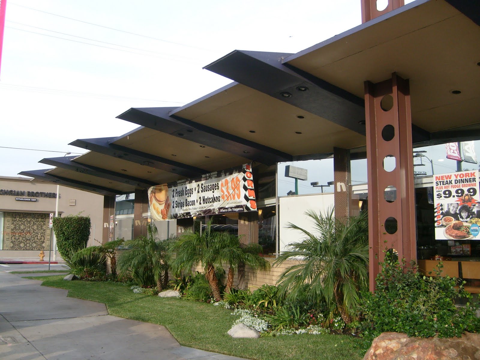
Pann's includes an angular edifice and large plate glass windows and has been described as having "the classic coffee shop architecture". It was designed by Armet & Davis, who also designed the Hollywood Bowl and the original Norms Restaurant.

Here is a sample of the “googie” used in the address numbers and the door handle.


Tropical landscaping was included in the design.


The stonework and the space age roof lines almost make the restaurant a meeting of the Flintstones and the Jetsons.


It is also known as "the Frank Lloyd Wright of '50s coffee shops. Even the ventilation system was incorporated into the architectural design.


Pann's was featured in a story in the Los Angeles Times, "Going on a hunt for Googie architecture," which noted the restaurant's tilted roof and sign, tropical plants and exposed stone walls indoors and out, and glass windows wrapping around the restaurant. Pann's celebrated its 50th anniversary in 2008.

However, not all of the past 50's years have been smooth sailing for this futuristic coffee shop. In the early 1990's, the restaurant was in danger of being demolished and rebuilt beyond recognition. At this point, the Los Angeles Conservancy's Modern Committee got involved and worked collaboratively with Pann's second generation owner Jim Poulos towards a plan restoring Pann's to its former glory.

Also recently, Pann’s was featured in a local Los Angeles television show called “Cheap Eats.” Be warned, there are a lot of breakfast meats shown on this video. http://www.youtube.com/watch?v=ZuwyvoOMHE4

For those interested in visiting, Pann’s, it is located on 6710 La Tijera Blvd, Los Angeles, CA‎. (323) 776-3770‎ http://www.panns.com/

Saturday, November 21, 2009

Norm’s – Los Angeles (West Hollywood)

Norms Restaurants is a chain of diner-style coffee shops in Southern California. The chain was founded in 1949 by Norman Roybark. The first restaurant was located at Sunset Blvd. at Morningside in Hollywood. Norm's already had nine locations in 1962. There are currently 17 locations in Los Angeles, Orange and Riverside counties.

The first Norms opened on La Cienega Boulevard in 1957 featuring a distinctive angular and brightly colored style that came to be known as Googie architecture. Key characteristics include concrete walls, large glass windows, jutting roof, and a neon marquee. The first Norms restaurant was designed by the architecture firm of Armet & Davis.

Here is a close up on the cool sign.


The interior of Norms Restaurant is still interesting and wisely the sprucing up they have done is with Mid-Century Modern fixtures. Located in a congested area of town, but it has its own free parking, which is a big plus. Many Norms now have given up all traces of the great Googie signs that this place still has.

For those interested in visiting the original Norm’s, it is located on 470 N. La Cienega Blvd., Los Angeles, CA 90048. (310) 657-8333 http://www.normsrestaurants.com/

Friday, November 20, 2009

Bob’s Big Boy – Toluca Lake, California

Big Boy is a restaurant chain started in 1936 by Bob Wian, in partnership with Arnold Peterson in Glendale, California. The chain is best known for its trademark chubby boy in red-and-white-checked overalls holding a Big Boy sandwich (double-decker cheeseburger).

The inspiration for Big Boy's name, as well as the model for its mascot, was Richard Woodruff (1936-1986), of Glendale, California. When he was six years old, he walked into the diner Bob's Pantry as Bob Wian was attempting to name his new hamburger. Wian said, "Hello, Big Boy" to Woodruff, and the name stuck.

The Toluca Lake location was built in 1949, and is the oldest remaining Bob's Big Boy in America. It was designed by respected architect Wayne McAllister, incorporating the 1940's transitional design of streamline modern style while anticipating the free-form 50's coffee shop architecture. The towering BOB's sign is an integral part of the building design and its most prominent feature.

Here is a shot of the towering Bob's sign at night. You can see it for several blocks away on Riverside Drive

The restaurant was honored in 1993, receiving the designation as a "State Point of Historical Interest" by the state of California. The current owner (the MacDonald Family) acquired control of the restaurant in 1993 and began to restore it to its past glory.

Here are some close up shots featuring the unique door handles with the “B” script, as well as the "Coffee Shop" sign over the outdoor seating area


For those interested in visiting, the original Bob’s Big Boy, it is located at 4211 W Riverside Dr., Burbank, CA 91505-4146. (818) 843-9334 http://www.bobs.net/